Santorini: Where Volcanic Earth Meets the Blue Aegean
Discover Santorini, the volcanic Greek island famed for whitewashed villages, blue domes, dramatic caldera cliffs, ancient Akrotiri, volcanic beaches, local wine and unforgettable Aegean sunsets.

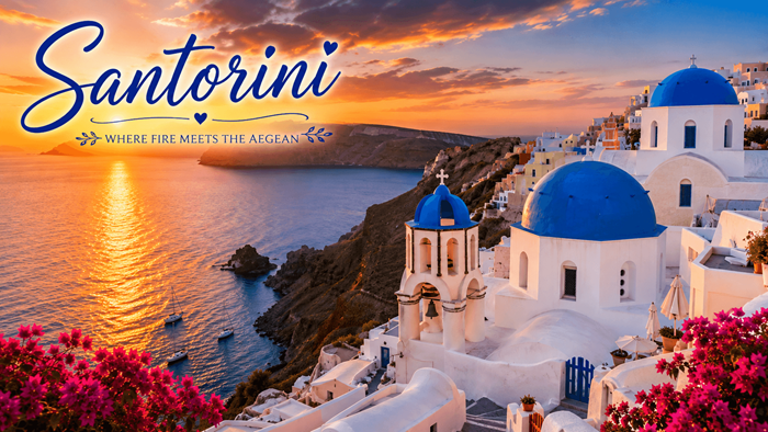
Brilliant white villages, deep blue domes, volcanic cliffs, and unforgettable sunsets make Santorini one of the most dramatic destinations in the Aegean. Yet the island is far more than a beautiful backdrop for photographs. Beneath its whitewashed architecture lies a landscape created by immense geological forces, while beneath its modern villages lies a history stretching back thousands of years.
Known officially as Thira, Santorini is the southernmost major island of the Cyclades. Its present-day landscape was shaped by repeated volcanic activity, most dramatically by the enormous eruption that transformed the island around 3,600 years ago. The resulting caldera, with steep cliffs rising above a sea-filled volcanic basin, is the defining feature of Santorini and one of the reasons its scenery is so distinctive. The island covers roughly 76 square kilometres and had 15,457 permanent residents according to the 2021 census.
For travellers, this creates an unusual combination. Santorini can feel luxurious and cosmopolitan, yet its character is inseparable from rugged volcanic terrain, traditional settlements, ancient archaeological remains, small churches, vineyards and beaches formed from black, red and grey volcanic material.
- Location: Southern Cyclades, in the Aegean Sea.
- Area: Approximately 76 square kilometres.
- Highest point: Profitis Ilias, reaching approximately 565 metres.
- Signature landscape: The volcanic caldera and its dramatic cliffs.
- Best known for: Oia sunsets, whitewashed villages, volcanic scenery and Cycladic architecture.
- Major historical attraction: The prehistoric settlement of Akrotiri.
The Volcanic Heart of Santorini
The easiest way to understand Santorini is to begin with its volcano. The island's extraordinary appearance is not simply the result of erosion or traditional Greek architecture. It is the visible expression of a huge geological story.
Thousands of years ago, Santorini formed part of a much larger volcanic island. A colossal eruption in the Late Bronze Age altered its shape dramatically. Much of the volcanic centre collapsed, allowing the sea to flood the resulting depression. What remains today forms the crescent-like outline of Thira, together with neighbouring islands including Thirasia and the smaller volcanic islets in the caldera. The eruption is commonly dated to around 1600 BC, although exact dating has been the subject of scientific study.
The caldera is therefore not simply a scenic bay. It is the flooded interior of a volcanic system. From villages such as Fira, Firostefani, Imerovigli and Oia, visitors look across the deep blue water toward the volcanic islands of Nea Kameni and Palea Kameni.
Nea Kameni provides one of the clearest reminders that Santorini's volcanic story is not confined to the distant past. Visitors can walk across its dark, rugged terrain, where volcanic rock and fumaroles create a landscape that can seem almost otherworldly. Boat excursions commonly combine the volcano with the thermal waters around Palea Kameni and views of Thirasia.
- Explore the caldera from the water for a different perspective of the cliffs.
- Walk across the volcanic landscape of Nea Kameni.
- See fumaroles and other evidence of continuing volcanic activity.
- Combine a volcano excursion with the thermal waters around Palea Kameni.
- Look back toward the main island to appreciate how dramatically the settlements cling to the caldera rim.
The Caldera: Where the Island Meets the Sea
The caldera is the geographical feature that gives Santorini much of its visual drama. On the western side of the island, the land rises sharply from the water, producing cliffs that can reach several hundred metres in height. Villages appear to hang from the upper slopes, with houses, churches, terraces and pathways layered across the volcanic rock.
This unusual topography has influenced almost everything about Santorini. Architecture had to respond to the steep terrain, available building materials and limited flat land. Traditional cave houses were carved into volcanic rock, while settlements developed along the contours of the cliffs rather than following a conventional grid. The result is an architecture that seems to grow directly from the landscape.
From the caldera rim, the view constantly changes with the weather and the position of the sun. In the morning, the volcanic cliffs can appear sharply defined against the Aegean. Around midday, the contrast between white buildings and dark rock becomes intense. As evening approaches, the light softens and the caldera takes on shades of gold, pink, orange and purple.
For many visitors, simply walking along the caldera edge is one of Santorini's defining experiences. The famous route linking Fira, Firostefani, Imerovigli and Oia combines village streets with open viewpoints, although the terrain can be uneven and exposed. Hiking in the hotter months is best planned for early in the day, particularly when temperatures are high.
- Fira: The island's capital and a lively centre for dining, shopping, museums and nightlife.
- Firostefani: A natural extension of Fira with caldera views and a quieter atmosphere.
- Imerovigli: A high viewpoint overlooking the caldera and volcanic islands.
- Oia: The celebrated northern village known for its architecture and sunset views.
Whitewashed Villages and Blue Domes
Santorini's architecture is perhaps its most recognisable visual feature. Whitewashed walls cascade down hillsides, punctuated by blue domes, small bell towers, arched doorways and narrow pathways. The famous combination of white and blue is strongly associated with the island, but Santorini's traditional architecture is more varied than its most photographed images suggest.
The island contains settlements built in different ways according to their location and history. Some follow the caldera rim, while others developed inland around fortified centres. Villages such as Pyrgos and Emporio reveal a different side of Santorini, with narrow lanes, old defensive structures and traditional buildings. Other settlements include cave houses carved into the volcanic terrain.
Oia is the most internationally recognisable of these villages. Its position above the northern part of the caldera, combined with its carefully preserved architecture, has made it one of Greece's most photographed destinations. White houses, blue-domed churches, windmills and old captain's houses create a visual identity that has become synonymous with Santorini.
Fira offers a contrasting experience. As the island's capital, it is more active and urban in character, with museums, restaurants, cafés, shops and nightlife alongside its caldera viewpoints. Visitors can move from busy streets into quieter lanes within minutes, making Fira an excellent starting point for exploring the island.
- Walk beyond the busiest viewpoints to discover quieter lanes and residential areas.
- Explore traditional settlements away from the main caldera centres.
- Look for cave houses and volcanic-rock construction.
- Visit historic churches and monasteries as part of the island's architectural landscape.
- Explore Pyrgos and Emporio for a different perspective on traditional Santorini.
Oia and the Legendary Santorini Sunset
Sunset is perhaps the single moment most closely associated with Santorini. Every evening, visitors gather along the western edge of Oia to watch the sun descend toward the Aegean. The attraction is not simply the sunset itself but the combination of changing light, volcanic cliffs, white buildings and the open sea.
As daylight fades, the hard contrasts of the afternoon soften. White walls take on warm colours, the caldera becomes darker and the sky stretches through a succession of gold, orange, pink and violet tones. The volcanic islands become silhouettes against the horizon.
The popularity of the spectacle means that Oia can become extremely busy around sunset, particularly during the peak summer season. Travellers who want a more relaxed experience can choose a viewpoint elsewhere along the caldera, book accommodation with a terrace, or watch the sunset from a boat on the water.
A boat-based sunset also changes the perspective completely. Instead of looking outward from the cliffs, travellers look back toward the island, seeing the villages illuminated above the caldera. Sailing is one of the activities promoted across Santorini, with excursions ranging from group trips to private experiences.
- Classic experience: Watch sunset from Oia.
- Quieter alternative: Choose another caldera village or viewpoint.
- On the water: Take a sailing or boat excursion around the caldera.
- Photography: Arrive before sunset to capture the changing light rather than only the final few minutes.
- Atmosphere: Stay after sunset as the villages begin to glow against the darkening volcanic cliffs.
Akrotiri: A City Preserved by Volcanic Ash
Santorini's volcanic history did not merely create its scenery. It also preserved one of the most remarkable archaeological sites in the Aegean.
Near the southern tip of the island lies Akrotiri, a prehistoric settlement that was buried beneath volcanic ash following the enormous eruption of the Late Bronze Age. The eruption covered streets, buildings, objects and artworks, protecting an extraordinary amount of evidence about Bronze Age life.
The settlement was far more sophisticated than the image of a simple prehistoric village might suggest. Archaeological discoveries have revealed multi-storey buildings, sophisticated infrastructure, household objects and colourful frescoes. The preservation of the site has allowed researchers to study aspects of architecture, trade, art and everyday life from thousands of years ago.
The archaeological site provides a powerful contrast with modern Santorini. Above ground, visitors see luxury accommodation, restaurants and famous viewpoints. At Akrotiri, they encounter the remains of an ancient urban society whose life was interrupted by the same volcanic forces that ultimately created the landscape seen today.
The Museum of Prehistoric Thera in Fira complements the archaeological site by displaying artefacts recovered from the island. Together, the museum and Akrotiri provide a deeper understanding of Santorini's prehistoric past.
- Explore the preserved streets and buildings of the prehistoric settlement.
- See archaeological evidence of sophisticated Bronze Age urban life.
- Learn about the eruption that buried the settlement beneath volcanic material.
- Visit the Museum of Prehistoric Thera in Fira for additional artefacts and context.
- Combine Akrotiri with nearby volcanic beaches for a full southern-island day.
Black, Red and Volcanic Beaches
Santorini's beaches look different from the pale sandy beaches found on many Greek islands. The island's volcanic origin is written directly into its coastline, where dark rocks, black sand and striking red cliffs create unusual contrasts with the blue Aegean.
Red Beach near Akrotiri is among the most recognisable. Its surrounding cliffs display intense red and rust-coloured volcanic material, producing a landscape that seems almost painted. Elsewhere, long stretches of darker volcanic coastline create a completely different beach experience.
Perissa, Perivolos and Agios Georgios form an extended southern beach area. Their dark volcanic sands and clear waters provide a more traditional seaside setting while retaining the distinctive geology that separates Santorini from many other Mediterranean destinations. Visit Greece describes the combined Perissa, Perivolos and Agios Georgios coastline as a five-kilometre stretch.
Vlychada is another memorable coastal landscape. Its cliffs have been sculpted into unusual forms by volcanic deposits, wind and water, creating a dramatic setting that feels very different from the caldera settlements.
- Red Beach: Famous for its red volcanic cliffs near Akrotiri.
- Perissa: A popular black-sand beach with extensive visitor facilities.
- Perivolos: Part of the long southern beach area.
- Agios Georgios: Another section of the southern volcanic coastline.
- Vlychada: Known for sculptural volcanic cliffs and a distinctive coastal landscape.
Vineyards on Volcanic Soil
Santorini's climate and volcanic soil have produced a wine culture unlike that of many other Greek islands. The island receives relatively little rainfall, while its volcanic ground and strong Aegean winds create challenging conditions for agriculture.
Traditional vines are often trained close to the ground in distinctive basket-shaped formations. This unusual method helps protect the grapes from strong winds and allows the vines to make use of limited moisture. The resulting vineyards are part of Santorini's agricultural identity as well as its culinary appeal.
The island is particularly associated with Assyrtiko, a white grape variety known for producing wines with pronounced acidity and mineral character. Wine tasting therefore offers another way to understand the volcanic landscape: the same environment that created the caldera also influences what can be cultivated on the island.
Visitors can explore wineries and vineyards in the island's interior, away from the busiest caldera viewpoints. A wine-focused excursion can provide a slower alternative to sightseeing, especially when combined with local food and views across the volcanic landscape.
- Visit traditional vineyards to see basket-trained vines.
- Taste wines produced from grapes grown in Santorini's volcanic environment.
- Look for Assyrtiko among the island's signature wines.
- Explore wineries inland rather than concentrating only on the caldera.
- Pair wine tasting with local dishes and regional ingredients.
The Flavours of the Island
Santorini's cuisine reflects the same environment that shaped its vineyards. Limited rainfall, volcanic soil and a long tradition of cultivation have encouraged the island to develop distinctive local produce.
Tomatoes, capers, fava and white aubergines are among the ingredients associated with Santorini. The island's famous cherry tomatoes are particularly suited to the dry conditions, while fava is traditionally prepared into a smooth dish that can be served as an appetiser or accompaniment.
Seafood naturally plays an important role in an island surrounded by the Aegean, while local tavernas provide opportunities to sample traditional Greek dishes alongside Santorini-grown ingredients. The best meals are often found when visitors move away from purely tourist-oriented menus and seek restaurants that emphasise regional produce.
Food also provides a connection between Santorini's present and its past. Farming has always required adaptation to the island's challenging conditions, and many local products are closely tied to the particular climate and volcanic ground.
- Fava: A classic Santorini speciality often served as a creamy dip or purée.
- Cherry tomatoes: Small, intensely flavoured tomatoes associated with the island.
- White aubergine: A distinctive local variety.
- Capers: An important ingredient in island cooking.
- Seafood: Fresh Aegean fish and seafood feature prominently in coastal dining.
Thirasia: A Different Side of the Caldera
Across the caldera from the main island lies Thirasia, a smaller island that forms part of the Santorini archipelago. It offers an opportunity to experience a quieter landscape and a more traditional atmosphere.
Thirasia was once connected to the main island before the prehistoric eruption transformed the geography of the region. Today it sits opposite Oia, with its own settlements, paths, churches and volcanic landscapes. Manolas is the island's main settlement, while Riva serves as its port. Thirasia covers approximately 9.25 square kilometres and had 319 residents in the 2011 census.
The island's smaller scale makes it particularly appealing to travellers who want to see another side of the Santorini landscape. Traditional cave houses, narrow routes and open views across the caldera create a striking contrast with the highly developed tourist centres of Fira and Oia.
Exploring Thirasia can also change the way Santorini itself is perceived. From the opposite shore, the main island's cliffs and villages become a vast geological panorama rather than a collection of individual streets and viewpoints.
- Visit Manolas for traditional architecture and caldera views.
- Explore quieter villages and paths.
- See Santorini from across the water.
- Look for traditional cave houses and older forms of island architecture.
- Combine the visit with a caldera boat excursion.
Walking, Hiking and Exploring the Landscape
Santorini is often presented as a destination for looking rather than doing, but the island offers plenty of opportunities for active exploration. Hiking routes cross the caldera landscape and connect villages, viewpoints and sections of the rugged coastline.
The walk between Fira and Oia is one of the best-known routes. It follows sections of the caldera rim and passes through Firostefani and Imerovigli before continuing toward the north. The scenery changes constantly, with views of the volcanic islands, whitewashed settlements and the Aegean opening out around the cliffs.
The terrain should not be underestimated. Uneven paths, steps, exposed sections and summer heat can make a walk considerably more demanding than it appears in photographs. Visit Greece recommends planning hiking activities early in the day during hot summer conditions.
Beyond hiking, the island's volcanic coastline creates opportunities for swimming, sailing, snorkelling and other water-based activities. A boat trip is particularly useful for understanding the scale of the caldera because the cliffs appear very different when viewed from sea level.
- Caldera hiking: Walk between villages while following the volcanic rim.
- Volcano walking: Explore the dark terrain of Nea Kameni.
- Sailing: Travel around the caldera and volcanic islands.
- Swimming: Enjoy the waters around the island's volcanic beaches.
- Boat excursions: Combine scenery, swimming and volcanic landmarks in one experience.
Fira: The Island's Lively Centre
Fira is the capital of Santorini and the main centre for administration, commerce and much of the island's nightlife. It occupies a prominent position along the caldera and combines spectacular scenery with the practical energy of a working town.
Visitors can browse shops, dine in restaurants, explore museums and wander through narrow streets before returning to viewpoints overlooking the volcano. The Museum of Prehistoric Thera makes Fira especially important for anyone interested in the island's ancient history.
Fira is also useful as a base for exploring the wider island. Roads and transport routes extend from the capital toward the beaches, archaeological sites and inland villages, while the caldera path provides a pedestrian connection toward the northern settlements.
Although Santorini is strongly associated with romantic escapes and luxury travel, Fira demonstrates that the island is also a functioning community. Behind the famous viewpoints is an everyday landscape of shops, homes, businesses, schools, churches and local services.
- Use Fira as a base for exploring the island.
- Visit the Museum of Prehistoric Thera.
- Walk the caldera edge toward Firostefani.
- Explore restaurants and cafés overlooking the volcanic landscape.
- Experience the island after sunset when Fira becomes one of its main nightlife centres.
Beyond the Caldera: Pyrgos, Emporio and the Interior
The most photographed parts of Santorini are concentrated along the caldera, but the interior reveals a quieter and more traditional side of the island. Villages such as Pyrgos, Emporio, Megalochori and Vothonas provide a different perspective on local life and architecture.
Pyrgos is built around a historic fortified settlement and rises toward Profitis Ilias, the island's highest mountain. From elevated points, visitors can see across much of Santorini and appreciate the relationship between the island's vineyards, villages and volcanic terrain.
Emporio is another important inland settlement. Its narrow streets and historic fortified architecture offer a glimpse of Santorini's defensive past, while its position provides convenient access to the southern beaches. Official local information describes Emporio as one of the island's larger villages and highlights its preserved Kasteli.
Megalochori offers a more relaxed atmosphere, with traditional homes, churches and village squares. Exploring these settlements can be particularly rewarding for travellers who want to experience Santorini beyond the iconic blue-domed viewpoints.
- Pyrgos: Historic village with panoramic views and a fortified core.
- Emporio: Large traditional settlement with preserved defensive architecture.
- Megalochori: Peaceful village known for traditional houses and churches.
- Vothonas: A settlement associated with distinctive cave architecture.
- Messaria: An inland village surrounded by agricultural landscapes and vineyards.
Experiencing Santorini Through the Seasons
Santorini's character changes considerably according to the season. Summer brings long days, hot weather, busy streets and the greatest concentration of visitors. Spring and autumn can offer a more balanced experience, with milder conditions for walking and sightseeing.
The official tourism information recommends spring through autumn for several outdoor experiences, while noting that summer hiking should be approached carefully because of high temperatures and humidity.
Summer is ideal for travellers whose priorities are swimming, sailing, long evenings and the full Mediterranean holiday atmosphere. However, the busiest viewpoints and villages can become crowded, particularly around sunset.
Spring can bring a fresher appearance to the landscape, while autumn combines warm weather with a gradual reduction in visitor numbers. Winter is much quieter, although some tourism businesses operate seasonally and the island has a very different atmosphere from its famous summer image.
- Spring: Pleasant for walking, sightseeing and exploring villages.
- Summer: Best suited to beach life, sailing and long evenings, but generally busiest.
- Early autumn: Warm conditions with opportunities for swimming and outdoor exploration.
- Late autumn: Quieter and increasingly suited to cultural and village exploration.
- Winter: The calmest season, revealing a more local side of the island.
A Landscape Made for Photography
Santorini's visual appeal comes from contrast. Brilliant white buildings stand against dark volcanic rock. Deep blue water sits beneath red and brown cliffs. Tiny churches appear above enormous expanses of sea. Ancient ruins coexist with contemporary hotels, while vineyards occupy dry hillsides below the caldera.
The island also rewards photographers who move beyond the obvious viewpoints. Oia's famous sunset may be the most recognisable image, but sunrise can provide quieter conditions. Inland villages reveal textured stone walls and narrow lanes, while the southern coast offers unusual geological formations.
Light is particularly important. The strong Mediterranean sun can create intense midday contrast, whereas early morning and late afternoon bring softer shadows and richer tones. From the caldera, changing weather can dramatically alter the colour of the sea and cliffs.
- Photograph the caldera in early morning for softer light and quieter streets.
- Look for architectural details rather than photographing only wide panoramas.
- Explore inland villages for textures, stonework and traditional doors.
- Use the volcanic beaches to capture colour contrasts.
- Photograph the island from the water to reveal the full height of the caldera cliffs.
Beyond the Postcard Image
Santorini's famous image is so powerful that it can be easy to overlook everything outside the postcard. The blue domes and sunsets are real, but they represent only one part of a much larger story.
The island is simultaneously a volcanic landscape, an archaeological destination, an agricultural community, a collection of historic villages and one of the world's most recognisable holiday destinations. Its identity comes from the interaction of these elements rather than from any single attraction.
That is why a rewarding visit can involve very different experiences in the same day. A morning might begin with a walk along the caldera, followed by an archaeological visit to Akrotiri. The afternoon could be spent among vineyards or on a volcanic beach, before ending with sunset above the Aegean.
The most memorable experiences often come from seeing the connections between these places. The volcano created the caldera, the caldera influenced the villages, the volcanic soil shaped agriculture, and the eruption preserved Akrotiri. Santorini's landscape, history, architecture and food are all parts of the same story.
- Combine scenery with history rather than focusing exclusively on viewpoints.
- Visit at least one inland village as well as a caldera settlement.
- Explore Akrotiri to understand the island's prehistoric past.
- Experience the volcanic landscape from both land and sea.
- Try local food and wine to discover another side of Santorini.
- Allow time for quieter areas away from the most photographed locations.
Sources and Further Reading
- Revised Minoan eruption volume as benchmark for large volcanic eruptions — Nature Communications, 2023. This peer-reviewed research reassesses the volume and geological development of the approximately 1600 BCE Minoan eruption using seismic, sedimentological and geological evidence, providing authoritative context for Santorini's volcanic history.
- Evolution of Santorini Volcano dominated by episodic and rapid fluxes of melt from depth — Nature Geoscience, 2012. This study examines the behaviour of the Santorini volcanic system using GPS and satellite radar observations, offering scientific context for the island's continuing volcanic activity and geological evolution.
- Hazardous explosive eruptions of a recharging multi-cyclic island arc caldera — Nature Geoscience, 2024. This research examines Santorini's longer-term volcanic development, historical eruptions and the evolution of its caldera system, making it a useful reference for understanding the island's geological significance.
- Constraining the landscape of Late Bronze Age Santorini prior to the Minoan eruption: Insights from volcanological, geomorphological and archaeological findings — Journal of Volcanology and Geothermal Research, 2020. This peer-reviewed study combines volcanological, geomorphological and archaeological evidence to reconstruct Santorini's landscape before the major Bronze Age eruption.
- Temporal evolution of the Minoan eruption (Santorini, Greece), as recorded by its Plinian fall deposit and interlayered ash flow beds — Journal of Volcanology and Geothermal Research, 2001. This detailed volcanological study examines the sequence and changing behaviour of the Minoan eruption through its preserved deposits.
- Geoarchaeological tsunami deposits at Palaikastro (Crete) and the Late Minoan IA eruption of Santorini — Journal of Archaeological Science, 2008. This archaeological and geological research investigates evidence associated with the eruption's wider effects across the Aegean, helping place Santorini within its broader Bronze Age environmental context.
- 2021 Population and Housing Census: Resident Population Results — Hellenic Statistical Authority (ELSTAT), 2023. Greece's official national statistical authority provides the underlying population census data for municipalities and regions, making this the appropriate reference for demographic information concerning Santorini and its residents.
- Revised estimates for the volume of the Late Bronze Age Minoan eruption, Santorini, Greece — University of Bristol, School of Earth Sciences. This peer-reviewed research contribution provides additional geological analysis of the Minoan eruption and the relationship between eruption deposits and the Santorini caldera.
Conclusion
Santorini is an island where geology, history, architecture and everyday life come together in an extraordinary Aegean landscape. Its brilliant white villages and blue-domed churches may be the images that first attract visitors, but the island's deeper character comes from the volcanic forces that shaped its cliffs, caldera, beaches and fertile ground. From the prehistoric remains of Akrotiri and the volcanic terrain of Nea Kameni to the vineyards, traditional villages and dramatic coastline, Santorini offers far more than its celebrated sunsets. Walking between Fira and Oia reveals the scale of the caldera, while exploring Pyrgos, Emporio and other inland settlements provides a quieter view of traditional island life. Local food and Assyrtiko wine add another dimension, connecting modern visitors with the agricultural traditions developed in Santorini's demanding volcanic environment. Whether experienced from a caldera viewpoint, a black-sand beach, a village lane or a boat sailing beneath the cliffs, Santorini remains one of the Mediterranean's most distinctive destinations. Its landscape is simultaneously beautiful and geological, ancient and modern, peaceful and lively, creating the rare feeling of travelling through a place whose natural history is visible almost everywhere.